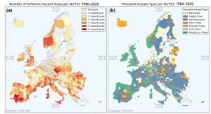
The COMPASS project recently released a gridded dataset of global exposure (population, gross domestic product and net fixed asset value) at a spatial resolution of 30 arc seconds (≈0.93 km at the equator) and lower. The data span from year 1850 to 2100, have an annual temporal resolution and include five future trajectories consistent with the Shared Socio-economic Pathways (SSPs). The dataset is generated by an algorithm and coded in Python that combines three layers of input data (as also illustrated in the figure below):
- A database of national-level historical and projected timeseries of population, gross domestic product (GDP) and fixed asset value for all countries of the world for 1850-2100;
- A database of subnational-level historical GDP per capita (for selected countries, where available);
- External gridded datasets of population and build-up area

The data is stored on the COMPASS project Zenodo repository (https://doi.org/10.5281/zenodo.14892500) and contains, apart from the exposure datasets, the documentation, input data and code for producing additional datasets at other spatial resolutions and/or specific timespan according to user needs. The code is hosted on the COMPASS Github repository: https://github.com/HORIZON-COMPASS/Exposure-and-vulnerability-modelling.
More information can be found in the following COMPASS project Deliverable:
Paprotny, D. (2025): Exposure datasets at multiple scales. Horizon Europe project COMPASS. Deliverable D3.1.